

Interpretation challenges related to thick low- and high-resistivity layers in electrical resistivity surveys
1
Faculty of Civil Engineering, Warsaw University of Technology, Poland
2
Department of Engineering Geology and Shallow Geothermal Energy, Polish Geological Institute – National Research Institute, Poland
3
Faculty of Civil Engineering,, Warsaw University of Technology, Poland
These authors had equal contribution to this work
Submission date: 2025-09-29
Final revision date: 2025-12-09
Acceptance date: 2025-12-16
Publication date: 2026-03-04
Corresponding author
Anna Lejzerowicz
Faculty of Civil Engineering, Warsaw University of Technology, Al. Armii Ludowej 16, 00-637, Warsaw, Poland
Faculty of Civil Engineering, Warsaw University of Technology, Al. Armii Ludowej 16, 00-637, Warsaw, Poland
Archives of Civil Engineering 2026;72(1):435-449
KEYWORDS
Electrical Resistivity Tomography (ERT)geophysical methodsgeotechnical investigationshigh-resistivity layerslow-resistivity layerssignal attenuation
TOPICS
ABSTRACT
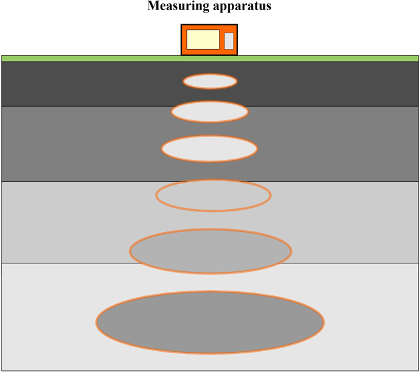
Electrical Resistivity Tomography (ERT) is a versatile and widely applied geophysical method for subsurface imaging, but its reliability is strongly influenced by geological conditions. This study discusses principal challenges in surveys within thick low- and high-resistivity complexes, which distort inversion results and complicate hydrogeological and geotechnical interpretation. In low-resistivity packages (e.g., clays, marls), resistivity values are underestimated, while signals from deeper layers are attenuated, often causing downward displacement of boundaries. In high-resistivity environments (e.g., dry sands, silts), thin conductive interbeds are either masked or appear with artificially elevated resistivity values. Both situations reduce interpretational resolution and increase the risk of overlooking critical geological features. The paper emphasizes the role of survey resolution, controlled by electrode spacing, array configuration, and measurement density. Since resolution decreases with depth, small or thin structures are more reliably imaged in the shallow subsurface, whereas deeper horizons are prone to distortions. The integration of ERT results with borehole data is indispensable for constraining ambiguities and validating inversion outcomes. In addition, vertical resistivity-gradient analysis is proposed as a complementary tool, capable of revealing subtle lithological transitions that may remain undetected in conventional resistivity sections. Through case studies, it is shown how thick resistivity packages affect subsurface models and presents strategies for improving interpretation, including optimized survey design, gradient analysis, and borehole correlation. Despite inherent limitations, ERT remains effective for hydrogeological and engineering investigations, provided that methodological constraints and interpretational uncertainties are carefully addressed.
Share
RELATED ARTICLE
| eISSN: | 2300-3103 |
| ISSN: | 1230-2945 |
We process personal data collected when visiting the website. The function of obtaining information about users and their behavior is carried out by voluntarily entered information in forms and saving cookies in end devices. Data, including cookies, are used to provide services, improve the user experience and to analyze the traffic in accordance with the Privacy policy. Data are also collected and processed by Google Analytics tool (more).
You can change cookies settings in your browser. Restricted use of cookies in the browser configuration may affect some functionalities of the website.
You can change cookies settings in your browser. Restricted use of cookies in the browser configuration may affect some functionalities of the website.