

Accuracy analysis in determining the location of underground objects using GPR involving lidar data
1
Faculty of Civil Engineering, Warsaw University of Technology, Poland
2
Faculty of Geodesy and Cartography, Warsaw University of Technology, Poland
Submission date: 2023-11-12
Final revision date: 2024-01-22
Acceptance date: 2024-01-30
Publication date: 2024-06-19
Corresponding author
Anna Lejzerowicz
Faculty of Civil Engineering, Warsaw University of Technology, Al. Armii Ludowej 16, 00-637, Warsaw, Poland
Faculty of Civil Engineering, Warsaw University of Technology, Al. Armii Ludowej 16, 00-637, Warsaw, Poland
Archives of Civil Engineering 2024;70(2):611-628
KEYWORDS
TOPICS
ABSTRACT
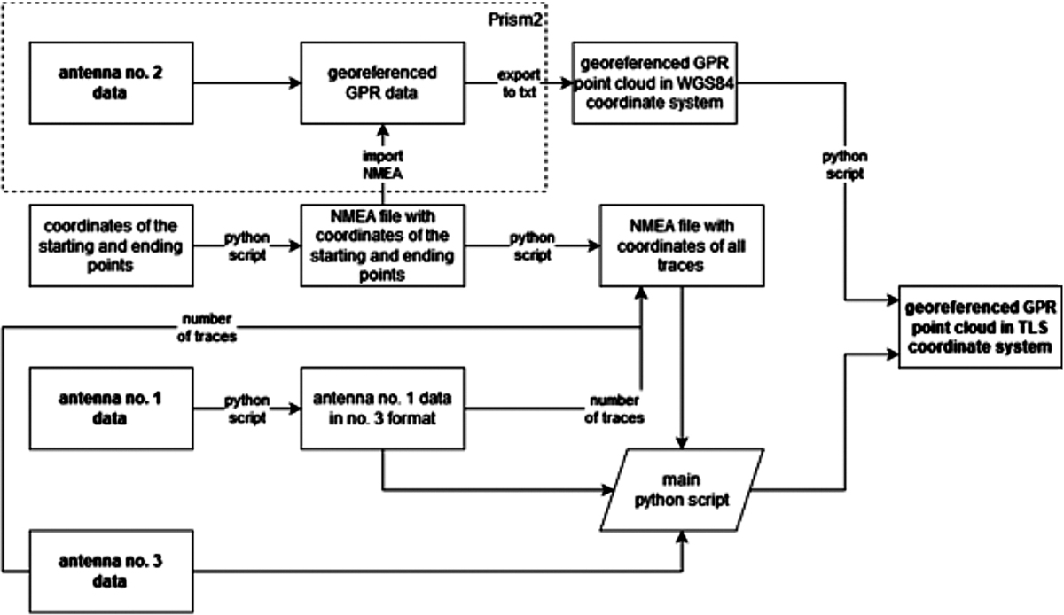
Ground penetrating radar (GPR) is one of the most useful non-destructive techniques for locating underground objects. Advancements in this technology have facilitated the development of new sensors over the past decade. In this paper, an accuracy assessment of the location of underground objects using various GPR antennas is presented. To achieve the stated goals, measurements of 5 concrete slabs, reinforced with steel bars of various diameters and located at variable depths were taken. The experiment includes the usage of three GPR antennas to assess the format, characteristics, and differences of extracted data. This set of antennas from different manufacturers varied in terms of operating frequency. Additional lidar data from TLS (terrestrial laser scanning) was utilized in the methodology to provide precise surface measurements and therefore, external orientation of the surveyed data. The experiment allowed for the determination of vertical and horizontal accuracy for three tested antennas and the assessment of increasing errors value with greater depth of the measured items, which is important for surveying accuracy forecasting.
Share
RELATED ARTICLE
| eISSN: | 2300-3103 |
| ISSN: | 1230-2945 |
We process personal data collected when visiting the website. The function of obtaining information about users and their behavior is carried out by voluntarily entered information in forms and saving cookies in end devices. Data, including cookies, are used to provide services, improve the user experience and to analyze the traffic in accordance with the Privacy policy. Data are also collected and processed by Google Analytics tool (more).
You can change cookies settings in your browser. Restricted use of cookies in the browser configuration may affect some functionalities of the website.
You can change cookies settings in your browser. Restricted use of cookies in the browser configuration may affect some functionalities of the website.